

Nowadays extreme weather events are a reality expected any time in modern urban societies. Lisbon municipality is no exception. The challenges highlighted by climate change projections up to 2100, report four main scenarios for the city of Lisbon: a rise in mean sea level, an increase in temperature, a decrease in rainfall and an increase in extreme weather events. With respect to the last scenario, an increase in the frequency and severity of extreme weather situations such as urban flash-floods combined with a maximum high tide, storm surge and rising the sea level, investment in a joint preventive policy based on a sustainable approach to minimize expected impacts is urgent.
Based on the commitments assumed by Lisbon’s municipality, the climate change resilience strategy that is currently under development focuses on flood risk, prioritises investment on planning, implementing and building back better adaptation and mitigation strategies, and reducing impacts and likely damage in highly urbanised areas.
The use of Geographic Information Systems (GIS) for addressing the study of flooding risk is recognised as a powerful tool to analyze data from different sources, assess the most affected areas and also improve decision-making processes associated with flood management. It’s important to remember that Lisbon floods are unpredictable events that can occur in less than 1 hour due to heavy rain (flash floods with overload of drainage systems), or corresponding long periods of rainfall (floods with rising water levels).
To assess the main flood risk areas, the Lisbon municipality used spatial analysis tools to combine physical and socio-urban variables with historical flooding situations identified by the emergency services. The analysis layers are:
- topographical relief with valleys and low slope areas interspersed
- the primitive hydrological network
- the contiguous location to the Tagus estuary (riverfront within 20.5 km)
- the rise of mean sea level (0.3 mm/year)
- the effect of direct high tide combined with storm surge
- the differences of local tide along the riverside front
- the failure of the drainage system capacity (image 1 and 2)
- the level of soil permeability
- underground construction and its influence on the natural hydrographic network.
The Resilience framework developed under the ongoing EU Horizon 2020 project RESCCUE which has been applied in Lisbon, is another strategy to measure resilience in a flood scenario, taking into account several dimensions (organisational, spatial, functional and physical), to promote the reassessment of climate change adaptation strategies and to strengthen policies between other cities (Bristol and Barcelona).
The approach that is being developed by the municipality to promote resilience to climate change is to invest in a participatory process as a way to strengthen partnerships, share knowledge and information (open data), educate and train different target audiences. It’s important to remember that today, Lisbon is a complex system with more than 1,000,000 citizens who live, work, study, circulate and visit the city, the majority of which are Portuguese. This approach allows Lisbon to highlight the investment made in offering a better city for people to live in now, and in the future.

Figure 1: Image showing the likely failure of Lisbon’s drainage system capacity, current flood scenario.
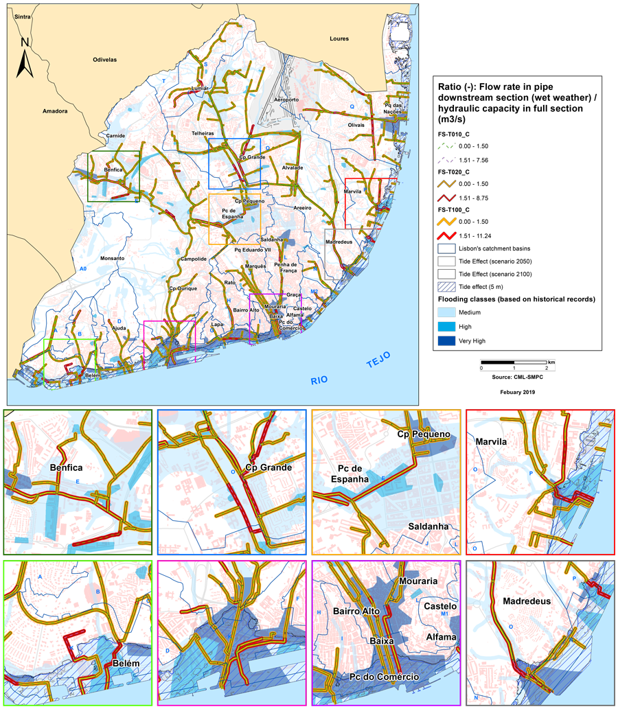
Figure 2: Image showing the likely failure of Lisbon’s drainage system capacity under a possible future scenario.